PerúSAT-1: Five Years Serving Peru
PerúSAT-1: Five Years Serving Peru
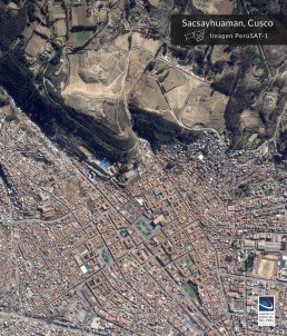
“All the users of the satellite system have generated products that benefit the population; especially in Disaster Risk Management, a very important sector in our country. Likewise, we must continue working to maintain our presence in space, since we have shown, and the user institutions confirm it, how important satellite information is in decision-making,” said FAP Major General José Antonio García Morgan, institutional head of the Peruvian Space Agency.PerúSAT-1 was built by Airbus Defense and Space in a record time of two years and orbits the Earth at an altitude of 702.5 km, acquiring up to 300 images a day, providing Peru with the most advanced optical satellite in the region. By design, a further five years of useful life remain; however, specialists from the Space Agency calculate that a few additional years will be possible depending on fuel and maneuvers performed.
"It is a great pleasure for us to celebrate this important date with our clients and friends in Peru," said Jean Marc Nasr, Head of Space Systems at Airbus. “We committed to deliver a complete state-of-the-art system to help develop Peru's space capabilities and these first five years bear witness to this. Peru can continue to count on the best of our satellite technology in the future.”In addition to the latest-generation optical satellite, the PerúSAT-1 program included a ground segment for control, reception and processing of images, located at CNOIS in Pucusana and also built by Airbus Defense and Space. The project developed Peruvian skills in space technologies, satellite operation and applications for image processing. In total, more than 80 Peruvian specialists benefited from this technology transfer program, both in Toulouse and Lima. Many Peruvian institutions work with satellite information including the National Civil Defense Institute (INDECI), the National Commission for Development and Life without Drugs (DEVIDA), the Ministry of Transport and Communications (MTC), the National Forest Service (SERFOR), the National Centre for the Estimation, Prevention and Reduction of Disaster Risk (CENEPRED), the Geological, Mining and Metallurgical Institute (INGEMMET), the Ministry of Agrarian Development and Irrigation (MIDAGRI), the Armed Forces, the Ministry of the Environment (MINAM), the National Geographic Institute (IGN), the National Service of Natural and Protected Areas by the State (SERNANP), and the Environmental Assessment and Enforcement Agency (OEFA), among others.