Three ‘Sleeping Beauties’ Await Their Turn in Orbit
Three ‘Sleeping Beauties’ Await Their Turn in Orbit
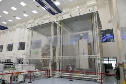
Albert Zaglauer, head of Earth Observation Systems, says: “The work of Europe's Copernicus program is vital. It monitors our planet’s health for the cost of just one cup of coffee per citizen per year.”Sentinel-2C, is currently set for launch in 2024. The exact launch date will be decided by ESA and the European Union depending on several variables, one being the end of life of Sentinel-2A. Sentinel-2D is fully integrated and functionally tested. The next step will be the environmental test campaign, which will begin when more information is available about the launch date for Sentinel-2C and the end of life of Sentinel-2B. The data gathered by Sentinel-2 satellites are used for monitoring land use and changes, soil sealing, land management, agriculture, forestry, natural disasters (floods, forest fires, landslides and erosion) and to assist humanitarian aid missions. Environmental observation in coastal areas likewise forms part of these activities, as does glacier, ice and snow monitoring. The telescope structure and the mirrors are made of silicon carbide, first pioneered by Airbus to provide very high optical stability and minimize thermo-elastic deformation, resulting in an excellent geometric image quality. This is unprecedented in this category of optical imagers. Sentinel-6B, will continue the vital work of Sentinel-6A, launched in 2020 to monitor our oceans. The satellite, which includes European and US instruments, successfully completed its environmental test campaign last year. There is a second round of environmental tests foreseen before launch. ESA/NASA plan to launch Sentinel-6B in late 2025 and then to initiate a one-year handover with the first Sentinel-6A “Michael Freilich” satellite which has been successfully operating in orbit since the end of 2020. The Copernicus Sentinel-6 will carry out high-precision measurements of ocean surface topography. Sentinel-6 measures its distance to the ocean surface with an accuracy of a few centimeters and uses this data to map it, repeating the cycle every 10 days, with the mission lasting up to seven years. It documents changes in sea-surface height, records and analyses variations in sea levels and observes ocean currents. Global sea levels are currently rising by an average of 3.3 millimeters a year as a result of global warming; this could potentially have dramatic consequences for countries with densely populated coastal areas. Each satellite carries a radar altimeter, which works by measuring the time it takes for radar pulses to travel to the surface and back again to the satellite. Combined with precise satellite location data, altimetry measurements yield the height of the sea surface. The satellites’ instrument package also includes an advanced microwave radiometer that accounts for the amount of water vapor in the atmosphere, which affects the speed of the altimeter’s radar pulses. Until they are called into action, the spacecraft will remain in hibernation, protected against any external disturbance. Airbus has played a crucial role in constructing the satellites and instruments for Copernicus since the start of the program in 1998, contributing its environmental expertise to all six Sentinel satellite missions and the new Copernicus next generation satellites: CRISTAL, LSTM, and ROSE-L missions. Sentinel satellites are part of Copernicus, Europe’s environmental monitoring program, which is led by the European Commission (EC) in partnership with the European Space Agency (ESA). The Copernicus Sentinels supply remote sensing data of the Earth, delivering key operational services related to environment and security. For more information on the Copernicus satellites: https://www.airbus.com/en/products-services/space/earth-observation/climate-missions
Albert Zaglauer, head of Earth Observation Systems, says: “The work of Europe's Copernicus program is vital. It monitors our planet’s health for the cost of just one cup of coffee per citizen per year.”Sentinel-2C, is currently set for launch in 2024. The exact launch date will be decided by ESA and the European Union depending on several variables, one being the end of life of Sentinel-2A. Sentinel-2D is fully integrated and functionally tested. The next step will be the environmental test campaign, which will begin when more information is available about the launch date for Sentinel-2C and the end of life of Sentinel-2B. The data gathered by Sentinel-2 satellites are used for monitoring land use and changes, soil sealing, land management, agriculture, forestry, natural disasters (floods, forest fires, landslides and erosion) and to assist humanitarian aid missions. Environmental observation in coastal areas likewise forms part of these activities, as does glacier, ice and snow monitoring. The telescope structure and the mirrors are made of silicon carbide, first pioneered by Airbus to provide very high optical stability and minimize thermo-elastic deformation, resulting in an excellent geometric image quality. This is unprecedented in this category of optical imagers. Sentinel-6B, will continue the vital work of Sentinel-6A, launched in 2020 to monitor our oceans. The satellite, which includes European and US instruments, successfully completed its environmental test campaign last year. There is a second round of environmental tests foreseen before launch. ESA/NASA plan to launch Sentinel-6B in late 2025 and then to initiate a one-year handover with the first Sentinel-6A “Michael Freilich” satellite which has been successfully operating in orbit since the end of 2020. The Copernicus Sentinel-6 will carry out high-precision measurements of ocean surface topography. Sentinel-6 measures its distance to the ocean surface with an accuracy of a few centimeters and uses this data to map it, repeating the cycle every 10 days, with the mission lasting up to seven years. It documents changes in sea-surface height, records and analyses variations in sea levels and observes ocean currents. Global sea levels are currently rising by an average of 3.3 millimeters a year as a result of global warming; this could potentially have dramatic consequences for countries with densely populated coastal areas. Each satellite carries a radar altimeter, which works by measuring the time it takes for radar pulses to travel to the surface and back again to the satellite. Combined with precise satellite location data, altimetry measurements yield the height of the sea surface. The satellites’ instrument package also includes an advanced microwave radiometer that accounts for the amount of water vapor in the atmosphere, which affects the speed of the altimeter’s radar pulses. Until they are called into action, the spacecraft will remain in hibernation, protected against any external disturbance. Airbus has played a crucial role in constructing the satellites and instruments for Copernicus since the start of the program in 1998, contributing its environmental expertise to all six Sentinel satellite missions and the new Copernicus next generation satellites: CRISTAL, LSTM, and ROSE-L missions. Sentinel satellites are part of Copernicus, Europe’s environmental monitoring program, which is led by the European Commission (EC) in partnership with the European Space Agency (ESA). The Copernicus Sentinels supply remote sensing data of the Earth, delivering key operational services related to environment and security. For more information on the Copernicus satellites: https://www.airbus.com/en/products-services/space/earth-observation/climate-missions